Quick Station Search:
Home
Albuquerque
(District 1)
Roswell
(District 2)
Deming
(District 3)
Las Cruces
(District 4)
Aztec
(District 5)
Santa Fe
(District 6)
Cimarron
(District 7)
Estancia Basin
Middle Rio Grande Basin
Fort Sumner Groundwater Basin
Lower Pecos Basin
Gila Basin
Mimbres Basin
Lower Rio Grande Basin
Las Animas Creek Basin
Hot Springs Basin
Salt Basin
Hueco Basin
Tularosa Basin
San Juan Basin
Rio Grande Basin
Santa Fe Basin
Pecos Basin
Canadian River Basin
Rio Grande at San Felipe, NM (USGS)
Jemez River Near Jemez, NM (USGS)
Jemez River Outlet Below Jemez Canyon Dam, NM (USGS)
North Floodway Channel Near Alameda, NM (USGS)
Rio Grande at Alameda Bridge at Alameda, NM (USGS)
Rio Grande Near Alameda, NM (USGS)
Rio Grande at Albuquerque, NM (USGS)
Tijeras Arroyo Near Albuquerque, NM (USGS)
South Div Channel Above Tijeras Arroyo Near Albuquerque, NM (USGS)
Rio Grande at Isleta Lakes Near Isleta, NM (USGS)
Rio Grande Near Bosque Farms, NM (USGS)
Rio Grande at State Hwy 346 Near Bosque, NM (USGS)
Rio Puerco Arroyo Chico Near Guadalupe, NM (USGS)
Arroyo Chico Near Guadalupe, NM (USGS)
Rio Puerco Near Bernardo, NM (USGS)
Rio Grande Floodway at San Acacia, NM (USGS)
Rio Grande at Bridge Near Escondida, NM (USGS)
Rio Grande Above US Hwy 380 Near San Antonio, NM (USGS)
Rio Grande Conveyance Channel at San Marcial, NM (USGS)
Rio Grande Floodway at San Marcial, NM (USGS)
Rio Grande Below Elephant Butte Dam, NM (USGS)
Rio Nutria Near Ramah, NM (USGS)
Zuni River Above Black Rock Reservoir, NM (USGS)
Bureau of Reclamation North MRGCD
Bureau of Reclamation South MRGCD
Albuquerque Bernalillo County Water Authority
FS-14
FS-14-S
FS-14-S-2
FS-14-S-4
FS-14-S-5
FS-14-S-6
FS-32
FS-32-X
FS-32-X-2
FS-44-X
FS-14-POD10
FS-44-X-2
Outfall
Above Outfall
Pecos River Near Puerto de Luna, NM (USGS)
Pecos River Below Sumner Dam, NM (USGS)
Pecos River Below Taiban Creek Near Fort Sumner, NM (USGS)
Pecos River Near Dunlap, NM (USGS)
Pecos River Near Acme, NM (USGS)
Pecos River Basin (USACE)
Fort Sumner
Roswell
Carlsbad
PDL-West
PDL-East
Arsenio Sanchez
FSID Main Drain
FSID Lower Drain
Pecos River Above Canon Del Uta Near Colonias, NM (USGS)
Pecos River Above Santa Rosa Lake, NM (USGS)
Pecos River Below Santa Rosa Dam, NM (USGS)
Pecos River Near Puerto de Luna, NM (USGS)
Pecos River Below Sumner Dam, NM (USGS)
Fort Sumner Main Canal Near Fort Sumner, NM (USGS)
Sand Gate Div From Ft Sumner Canal at Ft Sumner, NM (USGS)
Pecos River Below Taiban Creek Near Fort Sumner, NM (USGS)
Pecos River Near Dunlap, NM (USGS)
Hagerman Main
Nine Mile Dump
Felix Dump
Gilbert Gomez
Cecil Pollard
Brown
Pecos River Near Acme, NM (USGS)
Pecos River N Boundary (BLM Wetlands) Near Dexter, NM (USGS)
Pecos River S Boundary (BLM Wetlands) Near Dexter, NM (USGS)
Pecos River Near Lake Arthur, NM (USGS)
Pecos River Near Artesia, NM (USGS)
Pecos River (Kaiser Channel) Near Lakewood, NM (USGS)
Sibley/Edeal Pump
Sibley Well Spill
BR Supply
BRC Bypass
BR Canal
Blue Springs Ranch
Washington Ranch Return
Washington Ranch
Rattlesnake Springs #1
Rattlesnake Springs #2
Pecos River Below Brantley Dam Near Carlsbad, NM (USGS)
Pecos River at Damsite 3 Near Carlsbad, NM (USGS)
Carlsbad Main Canal at Head Near Carlsbad, NM (USGS)
Pecos River Below Avalon Dam, NM (USGS)
Pecos River Below Dark Canyon at Carlsbad, NM (USGS)
Blue Springs Above Diversions Near Whites City, NM (USGS)
Black River Above Malaga, NM (USGS)
Black River at Malaga, NM (USGS)
Pecos River Near Malaga, NM (USGS)
Pecos River at Pierce Canyon Crossing, NM (USGS)
Pecos River at Red Bluff, NM (USGS)
Delaware River Near Red Bluff, NM (USGS)
Virden Valley
Sunset
New Model
Sunset (GWC)
New Model (GWC)
Gila River Near Redrock, NM (USGS)
Gila River Below Blue Creek, Near Virden, NM (USGS)
Gila River at Duncan, AZ (USGS)
Mimbres
Grijalva
Montoya
Kenly #1
Kenly #2
Heuchling #1
Heuchling #2
Heuchling #3
Heuchling #4
Bear Canyon Reservoir
Ancheta-Galaz
Heredia
Llano
Tajo
Perrault
Duran
Go Forth
Swartz
Parra
Kimmick
Dominguez
Nan
Greenwald
Eby-Baca
Macedonio
Baca
Martin
Wardwell Herron
Tustin McIntosh
O'Sullivan McSherry Pena
Tigner #1
King
Lower Mimbres
Mimbres River at Mimbres, NM (USGS)
Holguin River Pump
EBID River Watch
Lower Las Animas Creek Ditch
San Miguel Community Ditch
Paxon River Pump
Ralph Edwards Pond
Las Palomas Community Ditch
Tularosa Creek Near Bent, NM (USGS)
Animas River
San Juan River
La Plata River
Twin Rocks
Ralston
Cedar
Graves-Atterbury
Stacey
Aztec
Sargent
Lower Animas
Lower Animas Rd 350
Farmers Irrigation
City of Aztec-River Pump
City of Aztec-Lower Animas
Eledge
Kello-Blancett
Halford-Independent
Independent
Ranchmans-Terrell
City of Farmington-Farmers Irrigation
City of Farmington Penny Lane Pump
Farmington Echo
North Farmington-Wright Leggett
Willett
Farmers Mutual
Animas River Near
Cedar Hill, NM (USGS)
Animas River Below
Aztec, NM (USGS)
Animas River at
Farmington, NM (USGS)
Citizens/BID
Turley
Hammond
Hammond Hwy 550
Jewett Valley
San Juan River Near Carracas, NM (USGS)
Los Pinos River at La Boca, CO (USGS)
Piedra River Near Arboles, CO (USGS)
Spring Creek at La Boca, CO (USGS)
Navajo Reservoir 40-day Inflow and Outflow
Navajo Indian Irrigation Project (NIIP)
Diversion From Navajo Reservoir (USBR)
San Juan River Near Archuleta, NM (USGS)
San Juan River at Farmington, NM (USGS)
Fruitland Canal Diversion Near Farmington, NM
Hogback Canal Diversion Near Waterflow, NM
San Juan River at Shiprock, NM (USGS)
San Juan River at Four Corners, CO (USGS)
San Juan River Near Bluff, UT (USGS)
Hillside
Greenhorn
Highland Park
La Plata Indian
Cunningham
Larkin-Reynolds
McDerrmott
Lefthand
Helton
Jackson
Pickering
La Plata River Near
Hesperus, CO (CO DWR)
Pine Ridge Ditch Near
Hesperus, CO (CO DWR)
Cherry Creek at the Mouth
Near Red Mesa, CO (CO DWR)
Government Draw Above Long Hollow Reservoir
Near Red Mesa, CO (CO DWR)
Long Hollow Above Long Hollow Reservoir
Near Red Mesa, CO (CO DWR)
Long Hollow Reservoir
Near Red Mesa, CO (CO DWR)
Long Hollow Below Long Hollow Reservoir
Near Red Mesa, CO (CO DWR)
La Plata River Below Mouth Long Hollow
Near Red Mesa, CO (CO DWR)
La Plata River at CO-NM
Stateline, CO (CO DWR)
Pioneer Ditch, CO (CO DWR)
Enterprise Ditch, CO (CO DWR)
La Plata River at
La Plata, NM (USGS)
La Plata River at
Farmington, NM (USGS)
Upper Chama
Lower Chama
NPT
Rio Nambe
Rio Pojoaque
Rio Tesuque
Rio Chupadero
Rio En Medio
Santa Fe River
La Cienega Creek
Rio Gallinas
Chama Town Ditch
M-B Ditch
Chama Valley Ditch
Valley Ditch
Chama Valley #1
Ranch 101 Ditch
Chama Valley #3
Canones Creek #1
Barranco Ditch
Sanchez y Chavez
Willow Creek Mesa Ditch
Plaza Blanca
Ensenada
Parkview
Porvenir
TA Community Ditch
Rio Chama Above
Chama, NM (USGS)
Rio Brazos at Fishtail Road Near
Tierra Amarilla, NM (USGS)
Rio Chama Near
La Puente, NM (USGS)
Willow Creek Below
Heron Dam, NM (USGS)
Abeyta Trujillo
J.P. Gonzales
Gonzales
Quintana
Valentine Martinez
La Puente
Mariano
Ferran
Tierra Azul
J.V. Martinez
Manzanares y Montoya
Rio de Chama
Martinez y Duranes
Chili
Hernandez
Chamita
Yungeh
Salazar
Rio Ojo Caliente At
La Madera, NM (USGS)
Rio Chama Below
Abiquiu Dam, NM (USGS)
Rio Chama Near
Chamita, NM (USGS)
Del Llano
Cerro Gordo
Santa Fe WWTP Discharge
Santa Fe River Above McClure Res
Near Santa Fe, NM (USGS)
Santa Fe River Near
Santa Fe, NM (USGS)
Santa Fe River Above
Cochiti Lake, NM (USGS)
La Cienega Irrigation District
La Cienega Spring
Guicu
Santa Fe River Above McClure Res
Near Santa Fe, NM (USGS)
Santa Fe River Near
Santa Fe, NM (USGS)
Santa Fe River Above
Cochiti Lake, NM (USGS)
City of Las Vegas
Gallinas Canal
Agapito
Gallinas River Weir at Storrie
Storrie
Los Vigiles
Grzelachowski
Los Romeros
Dolores de Las Vegas
Madre de Las Vegas
Round House
Pappen
Gallinas River Below Middle Diversions
Las Vegas WWTP Discharge
San Augustin
Concepcion
West Chaperito
Gallinas River Near
Montezuma (USGS)
Gallinas River Near
Lourdes (USGS)
Gallinas River at
Colonias (USGS)
High Line
Upper Consolidated
Lower Consolidated
Nueva
Llano
Comunidad
Ortiz
Gardunos
Jose G. Ortiz
Cano
Rincon
Las Joyas
Trujillos
Barranco Alto
Larga
Ancon de Jacona
Rio Nambe Above
Nambe Falls Dam (USGS)
Nambe Falls Reservoir (USGS)
Rio Nambe Below
Nambe Falls Dam (USGS)
Barranco
Otra Vanda
Rancho
Indios
San Ildefonso
Bauer Springs Ditch
Cajon Grande
Cy More
Madre
Medio
Tesuque Pueblo Pond
Los Ortizes
Los Ojitos
Romeros
Del Rio
Barranco Blanco
Tesuque Creek Above
Diversions (USGS)
Frank V. Ortiz
Chupadero Irrigation Co.
Vicente Ortiz
Del Molino
Rio en Medio
Cimarron River
Santa Clara Springs
Cieneguilla Creek
Sixmile Creek
Moreno Creek
Philmont Canal
Philmont Webster
Philmont Cito
Old Mill Ditch
Jackson Ditch
WS French Lake
CSC-CS UU Bar Urraca
CSC-Trujillo CS E-Line
CSC-CS #1
CSC-CS Highline
CS Honey
Upper Chase Ditch
Middle Chase Ditch
Miami Lake Long Flume
Philmont Urraca
Vallejo
North Rayado
South Rayado
CS Clayton Place
AVID Bubbler
Springer Ditch Highline
S.D.C. Town of Springer
Taylor Drop
Springer Ditch below Springer Lake
Eagle Tail Ditch Near Maxwell, NM (USGS)
Vermejo River Near Dawson, NM (USGS)
Cimarron River Below Eagle Nest Dam, NM (USGS)
Cimarron River Near Cimarron, NM (USGS)
Ponil Creek Near Cimarron, NM (USGS)
Rayado Creek Near Cimarron, NM (USGS)
Canadian River Near Taylor Springs, NM (USGS)
Sierra Ditch Near Chacon, NM (USGS)
La Sierra Ditch Near Holman, NM (USGS)
Mora River at LaCueva, NM (USGS)
Mora River Near Golondrinas, NM (USGS)
Coyote Creek Near Golondrinas, NM (USGS)
Canadian River Near Sanchez, NM (USGS)
Canadian River at Logan, NM (USGS)
Revuelto Creek Near Logan, NM (USGS)
Harper Ditch
Santa Clara Spring
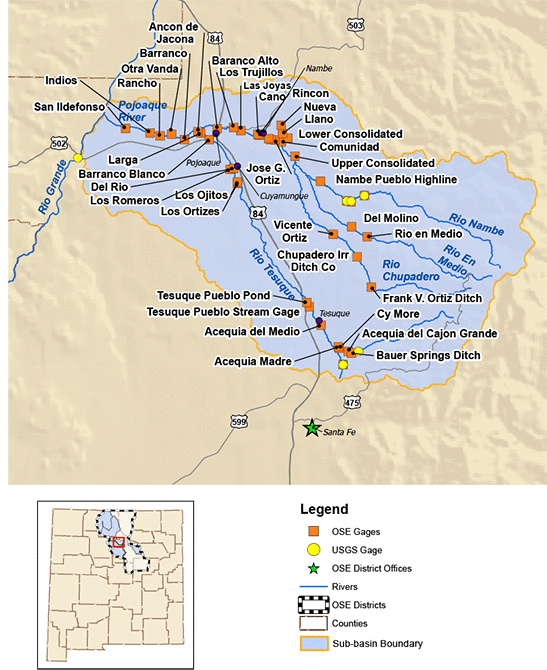
District 6 (Santa Fe): NPT Subbasin
NPT Subbasin
- Rio Nambe -
High Line
Upper Consolidated
Lower Consolidated
Nueva
Llano
Comunidad
Ortiz
Gardunos
Jose G. Ortiz
Cano
Rincon
Las Joyas
Trujillos
Barranco Alto
Larga
Ancon de Jacona
- Rio Pojoaque -
Barranco
Otra Vanda
Rancho
Indios
San Ildefonso
- Rio Tesuque -
Bauer Springs Ditch
Cajon Grande
Cy More
Madre
Medio
Tesuque Pueblo Pond
Los Ortizes
Los Ojitos
Romeros
Del Rio
Barranco Blanco
- Rio Chupadero -
Frank V. Ortiz
Chupadero Irrigation Co.
Vicente Ortiz
- Rio En Medio -
Del Molino
Rio en Medio
Other Streamflow Gages (External Links)
Rio Nambe Above Nambe Falls Dam (USGS)
Nambe Falls Reservoir (USGS)
Rio Nambe Below Nambe Falls Dam (USGS)
Tesuque Creek Above Diversions (USGS)