-- Provisional Data Subject To Revision --
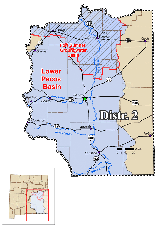
- Fort Sumner Groundwater Basin
- Vaughan Conservation Pipeline near Fort Sumner
| Well Name |
Date & Time |
Discharge (gpm) |
Gage Height(ft bgs)  |
Avg Daily Flow (gpm) |
| FS-14 |
04/21 16:59 |
NR
|
0.0
|
NR
|
| FS-14-S |
04/29 05:00 |
50
|
189.73
|
50
|
| FS-14-S-2 |
04/21 16:59 |
0
|
0.0
|
NR
|
| FS-14-S-4 |
04/21 16:59 |
0
|
0.0
|
NR
|
| FS-14-S-5 |
04/29 05:33 |
0
|
240.33
|
0
|
| FS-14-S-6 |
04/21 16:59 |
0
|
0.0
|
NR
|
| FS-32 |
04/21 16:59 |
0
|
0.0
|
NR
|
| FS-32-X |
04/29 04:46 |
0
|
118.09
|
0
|
| FS-32-X-2 |
04/29 03:47 |
0
|
-1020.84
|
0
|
| FS-44-X |
04/29 05:18 |
0
|
75.29
|
0
|
| FS-14-POD10 |
04/28 18:31 |
0
|
-62.72
|
NR
|
| FS-44-X-2 |
04/29 05:00 |
240
|
103.06
|
195
|
| Station Name |
Date & Time |
Discharge (cfs) |
Gage Height (ft) |
Avg Daily Flow (cfs) |
| Outfall |
NR |
NR
|
NR
|
NR
|
| Above Outfall |
04/29 05:25 |
0.0
|
NR
|
0.0
|
- Lower Pecos Basin
| Station Name |
Date & Time |
Discharge (cfs) |
Gage Height (ft) |
Avg Daily Flow (cfs) |
| PDL-West |
04/21 16:59 |
0.0
|
0.0
|
NR
|
| PDL-East |
04/29 05:00 |
14.23
|
1.45
|
14.2
|
| Arsenio Sanchez |
04/29 05:15 |
0.0
|
NR
|
0.0
|
| FSID Main Drain |
04/29 05:25 |
250.38
|
3.8
|
252.37
|
| FSID Lower Drain |
04/29 05:18 |
24.57
|
1.65
|
23.79
|
| Station Name |
Date & Time |
Discharge (cfs) |
Gage Height (ft) |
Avg Daily Flow (cfs) |
| Hagerman Main |
04/29 05:30 |
106.07
|
2.54
|
106.07
|
| Nine Mile Dump |
04/29 05:38 |
0.0
|
0.28
|
0.0
|
| Felix Dump |
04/29 05:37 |
0.0
|
-0.0
|
0.0
|
| Gilbert Gomez |
04/29 05:30 |
0.0
|
-0.14
|
0.0
|
| Cecil Pollard |
NR |
NR
|
NR
|
NR
|
| Brown |
04/29 05:23 |
0.0
|
-0.01
|
0.0
|
| Station Name |
Date & Time |
Discharge (cfs) |
Gage Height (ft) |
Avg Daily Flow (cfs) |
| Sibley/Edeal Pump |
04/29 05:30 |
0.26
|
0.26
|
0.26
|
| Sibley Well Spill |
04/29 05:38 |
0.53
|
0.17
|
0.02
|
| BR Supply |
04/29 05:38 |
13.28
|
0.69
|
9.65
|
| BRC Bypass |
04/29 05:38 |
0.0
|
0.0
|
0.0
|
| BR Canal |
04/29 05:30 |
8.98
|
0.54
|
8.65
|
| Blue Springs Ranch |
04/29 05:30 |
0.0
|
NR
|
0.07
|
| Washington Ranch Return |
04/29 05:30 |
4.02
|
NR
|
4.01
|
| Washington Ranch |
04/29 05:30 |
4.64
|
0.72
|
4.75
|
| Rattlesnake Springs #1 |
04/29 05:36 |
0.31
|
1.59
|
0.31
|
| Rattlesnake Springs #2 |
04/29 05:36 |
1.67
|
1.27
|
1.67
|
- Other Streamflow Gages (External Links)
-
Pecos River Above Canon Del Uta Near Colonias, NM (USGS)
-
Pecos River Above Santa Rosa Lake, NM (USGS)
-
Pecos River Below Santa Rosa Dam, NM (USGS)
-
Pecos River Near Puerto de Luna, NM (USGS)
-
Pecos River Below Sumner Dam, NM (USGS)
-
Fort Sumner Main Canal Near Fort Sumner, NM (USGS)
-
Sand Gate Div From Ft Sumner Canal at Ft Sumner, NM (USGS)
-
Pecos River Below Taiban Creek Near Fort Sumner, NM (USGS)
-
Pecos River Near Dunlap, NM (USGS)
-
Pecos River Near Acme, NM (USGS)
-
Pecos River N Boundary (BLM Wetlands) Near Dexter, NM (USGS)
-
Pecos River S Boundary (BLM Wetlands) Near Dexter, NM (USGS)
-
Pecos River Near Lake Arthur, NM (USGS)
-
Pecos River Near Artesia, NM (USGS)
-
Pecos River (Kaiser Channel) Near Lakewood, NM (USGS)
-
Pecos River Below Brantley Dam Near Carlsbad, NM (USGS)
-
Pecos River at Damsite 3 Near Carlsbad, NM (USGS)
-
Carlsbad Main Canal at Head Near Carlsbad, NM (USGS)
-
Pecos River Below Avalon Dam, NM (USGS)
-
Pecos River Below Dark Canyon at Carlsbad, NM (USGS)
-
Blue Springs Above Diversions Near Whites City, NM (USGS)
-
Black River Above Malaga, NM (USGS)
-
Black River at Malaga, NM (USGS)
-
Pecos River Near Malaga, NM (USGS)
-
Pecos River at Pierce Canyon Crossing, NM (USGS)
-
Pecos River at Red Bluff, NM (USGS)
-
Delaware River Near Red Bluff, NM (USGS)
-
Pecos River Basin (USACE)
|
|